The Lituya Bay Monster: How a 1,720-Foot Wave Redefined Geography and Global Tsunami Science
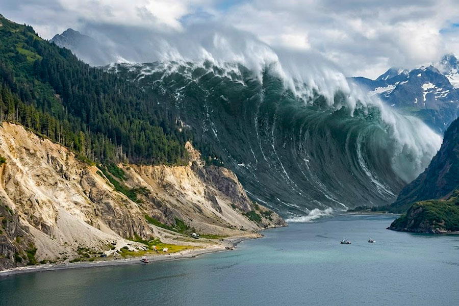
On July 9, 1958, a remote corner of Alaska witnessed an event that continues to defy imagination. A colossal wave, reaching a staggering height of 524 meters (1,720 feet), surged through Lituya Bay, stripping centuries-old forests down to bare bedrock. This was no ordinary tsunami; it was a megatsunami—a phenomenon so powerful it surpassed the height of the Empire State Building. As Chief Editor, I maintain that the story of Lituya Bay is not merely a chronicle of disaster but a profound lesson in the raw, unpredictable power of nature when tectonic shifts meet fragile glacial landscapes. We will dissect the mechanics of this “aquatic apocalypse” and explore why Alaska remains a high-risk zone in our changing climate.
Anatomy of a Catastrophe: The Fairweather Fault and 30 Million Cubic Meters of Rock
The disaster did not originate in the water but deep within the Earth’s crust. A magnitude 7.8 to 8.3 earthquake struck along the Fairweather Fault, which runs directly beneath Lituya Bay. This seismic rupture triggered a massive landslide that acted as the detonator for the megatsunami.
- The Slide: Approximately 30 million cubic meters of rock and ice plummeted from an elevation of 3,000 feet (900 meters) into the confined Gilbert Inlet.
- Displacement Effect: The impact of such a massive volume in a narrow fjord created a giant splash that surged up the opposite mountainside over half a kilometer high.
- Velocity: The wave raced across the bay at speeds exceeding 100 miles per hour (160 km/h), obliterating everything in its path.
- Environmental Scouring: The force was so great that it removed soil and vegetation up to an elevation previously considered safe from any maritime threat.
Survivors of the Abyss: The Howard Ulrich Story
The most remarkable aspect of the Lituya Bay event is the survival stories of those caught in the epicenter. Three small fishing boats were anchored in the bay that night. The survival of Howard Ulrich and his seven-year-old son remains a legend in maritime history.
- The Initial Shock: Ulrich was awakened by violent shaking. From his deck, he saw the mountains at the head of the bay behaving as if they were “exploding.”
- A Wall of Darkness: Minutes later, he witnessed a wall of water that he described as looking like a “black mountainside.”
- The Survival Maneuver: Ulrich managed to slacken his anchor chain and steer his boat directly into the wave. His vessel rode the crest, passing over the tops of massive spruce trees before descending safely on the other side.
- Losses: Tragically, the Wagner family’s boat was swept over the La Chaussee Spit; their vessel sank, and they were never found.
Comparative Analysis: Lituya Bay vs. Historical Tsunami Events
To grasp the scale of the 1958 event, we must compare it with other global disasters. Megatsunamis differ fundamentally from subduction-zone tsunamis in their formation and local impact.
| Event | Year | Max Wave Height | Trigger Mechanism | Fatalities |
|---|---|---|---|---|
| Lituya Bay (Alaska) | 1958 | 1,720 feet | Landslide into confined fjord | 5 people |
| Indian Ocean (Boxing Day) | 2004 | 100 feet | Undersea Megathrust Quake | ~230,000 people |
| Tohoku (Japan) | 2011 | 130 feet | Plate Tectonic Shift | ~16,000 people |
| Taan Fiord (Alaska) | 2015 | 633 feet | Glacial Retreat & Landslide | 0 (Remote area) |
| Krakatoa Eruption | 1883 | 140 feet | Volcanic Caldera Collapse | ~36,000 people |
21st Century Megatsunamis: Why Glacial Melting is the New Threat
While the 1958 event was triggered by an earthquake, modern science points to a new catalyst—climate change. Melting glaciers in Alaska are leaving mountainsides unsupported, creating the perfect conditions for new Lituya Bay-style events.
- The Barry Arm Threat: Scientists are monitoring an unstable slope in Barry Arm that could collapse, potentially generating waves up to 600 feet high.
- Permafrost Degradation: Rising temperatures weaken the “ice glue” that holds steep rock faces together.
- Early Warning Systems: The USGS is installing ground-motion sensors to provide critical minutes of warning to coastal communities like Whittier.
Geographical Legacy: The Trimline of History
Lituya Bay remains a living monument to that night. Decades later, the “trimline”—a sharp boundary between old-growth forest and younger vegetation—is still visible to the naked eye.
- Trimline Evidence: This line serves as a primary tool for geologists to measure the run-up height and energy of the water.
- Sediment Research: Layers on the bay floor allow researchers to reconstruct the bay’s history, revealing evidence of prehistoric megatsunamis.
- Scientific Tourism: Despite the risks, the bay attracts geologists and extreme nature enthusiasts seeking to witness the scar of the world’s largest wave.
FAQ: Frequently Asked Questions about Alaska Megatsunamis
- How could a wave reach 1,720 feet? It was a “run-up” caused by a massive splash in a narrow space, forcing water up the mountainside rather than across an open ocean.
- Is a megatsunami more dangerous than a regular one? Locally, yes. However, regular tsunamis travel thousands of miles and can impact entire ocean basins, whereas megatsunamis usually dissipate quickly.
- Can you survive such a wave? Howard Ulrich’s case proves it is possible if you are on a vessel in deep water and can point the bow into the wave.
- Where else could this happen? Any deep, narrow fjord with steep walls, such as those in Norway, Greenland, Chile, and British Columbia.
- Is it linked to global warming? Recent events, like the 2015 Taan Fiord wave, are directly linked to glacial retreat exposing unstable slopes.
- What happens if Barry Arm collapses? Waves could reach nearby towns like Whittier within 20 minutes, making rapid response systems vital.
- How many people died in 1958? Five people perished—two on a boat in the bay and three in nearby Yakutat Bay.
- How often do these events occur? Geological evidence suggests Lituya Bay experiences a major event every 50 to 100 years.
- Why is Lituya Bay so prone to this? Its unique T-shape and its location directly over the active Fairweather Fault create a high-risk environment.
- Can the wave damage still be seen today? Yes, the stark contrast in tree height and type along the shore clearly marks the wave’s path.